It didn’t seem to take me to the right place? It’s hard to tell, as OSMapping just zeroed in on my location anyway.
In any event, it just took me to a map of my local area without any form of pinpointing, or grid squares, as I don’t have the paid version, so, if someone else gave me a GR, and I searched for it, it doesn’t provide a pinpoint, or even a search square, just a wide map. I’m somewhat surprised it only uses 6 figures, without an option for even 8.
If anyone is interested in a good GPS locating app only (ie no maps) then GPS Status on android (may be an iOS one too) is awesome! For someone a bit geeky like me it’s interesting to use as it gives you all the direct output information from the various sensors on your phone. In the settings you can change all the units around including changing the location setting to pretty much anything you can think of (including OS Grid, 8 fig).
It’s not super useful for anything in particular, just an interesting app! 
You seem to be defending W3W’s business model, but complaining that you haven’t got access to OS Maps on your phone because you haven’t bought the maps? 
But OK, clicking on “OS Maps” does show you your current location (as determined by OS Locate). I think we’re mixing up 2 things here:
- giving a tool that can be used by someone in difficulty (e.g. a D of E group)
- a tool used by someone coordinating (to some extent) the rescue (e.g. the leader)
OS Locate is a free download, and has various sharing abilities (SMS, email, messenger, etc), which could be used by the group to let their leader know where they are. To be a RAFAC D of E exped supervisor you have to have an NGB qualification where you need the skills to read a GR on a map. Yes, I accept this gives you a 6 figure GR (100m x100m), rather than W3W’s 3m x 3m, but this has served Mountain Rescue Teams well enough for several decades 
The other advantage of GR over W3W is proximity - each neighbouring square in W3W has no relationship to its neighbours. Each square (at whatever granularity) in a GR system does have a (numerical) relationship to its neighbours
I’m not defending their business model, I just note that it worked for them, so that it’s now becoming an integrated system for the emergency services, whether they wanted it or not. I don’t have to like it, but I can respect the effort.
Anywho, I solved one problem this morning with the two systems not being easily convertible. Turns out it is, on a computer at least.
You just need this plug in for Chrome (Firefox does one too:)
Maps with what3words - Chrome Web Store (google.com)
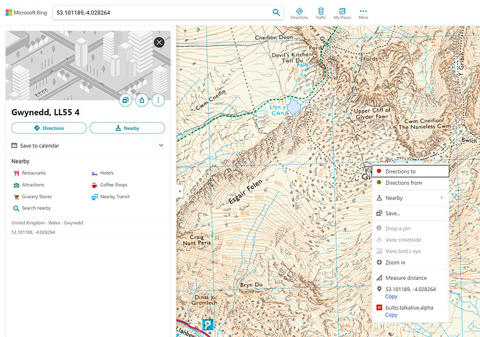
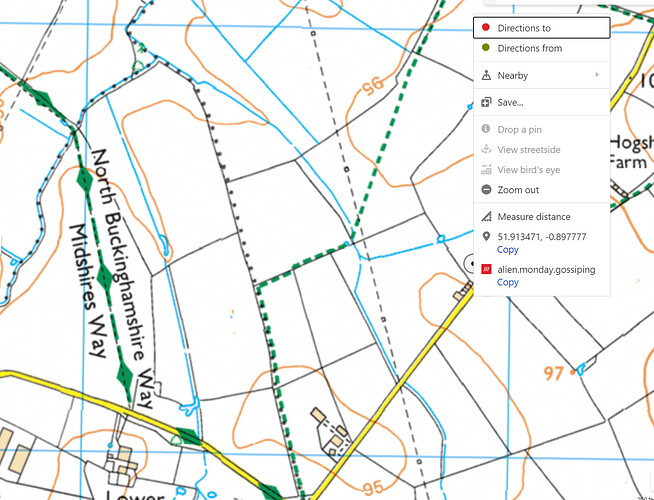
Then you can search for W3W locations within either Google Maps (which you of course, can do anyway), or, more importantly Bing Maps. just open Bing Maps and type in the code with /// ahead of it, so, to use Threader’s example earlier: (///bulbs.talkative.alpha)
Once you search for a location using a W3W in Bing maps. The plug in converts it into a Lat/Long and then you can select Bing’s free to use OS layer, and it gives you the Lat/Long, and pins the location on OS, so you can work out the GR on the map. like so:
This is also free.
(I wonder why that map of Gwynedd is on the slight screw-wiff on both Bing and whatever Threaders was using?)
I think I groaned out loud when I saw W3Ws was back on the recent threads, IMO it just makes for confusion, especially at half the time 999 won’t know what you’re on about if they haven’t subscribed to it. It also doesn’t translate well to other countries, adding to the confusion.
If you’re that lost/ in an emergency with a paper map you probably won’t have enough signal anyway for it to work properly
What, really, are the chances of that getting passed successfully on the radio? Or by mobile phone up a mountain in the wind? I mean, sure, you could read it out but it would be quicker to read a Lat/Long!
Text message, sure. But there’s a reason for RT procedures.
Who honestly uses RT on AT?
Look, it’s one tool out of many. It works, and it can, with a little effort be factored into a OS search.
You know instantly if it’s wrong, because even one word misspelt will be way off, look at it as a check sum for a dodgy grid ref, with a far higher degree of accuracy. Not once have I suggested that it should be the only way to find people, but it’s free, accurate and it works.
Having heard some terrible numerical mis-pronunciations over aviation radio (native English speakers - “normal” environment), I suggest that passing any form of numbers in a high stress situation could lead to incorrect transmission - including transposition of lat / long numbers?
Is spelling out a word phonetically likely to be easier? Maybe - perhaps more transmission time though.
A screenshot of the W3W location “words” can be sent by a 'phone too…
The emergency services certainly don’t use RT procdures ![]()
As we said before, heavy advertising. Including cookie tracking it seems…
How do the people behind w3w make their money?
Do you get another tranche of unsolicited ads etc?
What I’ve never got from the advert is how does he know where he is on the shoreline in order to know how to get his 3 words. Is he using a GPS or mapping tool? In which case use the lat/long or GR to pass to whoever. Is this not the position the majority would be in? Unless we are going to have routecards with strewn with 3 word combos. If you were in that bad a state would you really start faffing around to use another bit of software.
It’s a nice gimmick that looks good on an advert for an injured kayaker in backend of nowhere, but outside of that not much use and it requires everyone involved to have it, Lat and Long would work equally as well and easily obtained. I suppose in the advert the bloke was lucky they knew what he was on about, but then it is only an advert. He was as lucky to have sufficient signal. But then it’s an advert and can’t let technicalities like that get in the way.
I’ve been on expeds in normal countryside and we’ve not had a decent signal between us and neither have cadets, let alone being anywhere vaguely remote.
I’ve looked at where I work and there are dozens of squares, but it seems each square just refers to a vertical column, so you could be anywhere from the basement to 30th floor. But then you would give the address.
This is typical of software developers coming up with something they think is useful then trying to convince others it is.
I used it (as a passenger in a car) to report a multi-vehicle RTA on the opposite carriage way of the M25.
We were between junctions & the driver was not sure of distance from the last junction, or to the next (never mind the junction numbers & I hadn’t been monitoring); W3W was very quick to access, & report. No issues with the emergency operator & W3W.
I guess it’s about user friendliness to the average Joe?
I love maps. I enjoy looking at them, finding hidden features, and using them to navigate. But, I’m aware that some people just don’t get them, and asking them to give a grid ref when they’re in a warm, quiet, brightly lit classroom just causes them to fall to pieces. Plus, I don’t routinely carry maps when I’m walking somewhere like the local country park.
Google maps gives Lat Long coordinates, but how many average Joes know about, understand, and can use them? Plus, I have several acquaintances who refuse to use because of privacy concerns.
W3W is a simple concept for the average person to understand with no prior training, download just in case, and then open it if you need it.
I like it. Its not going to replace my map addiction, nor Google maps, but it is on my phone, just in case might need it in the future?
Yes. The W3W app itself does that.
GPS doesn’t require signal, so the only issue there is a phone call. SOS calls are routed through any available network, so there’s a chance that you couldn’t call your mum, but you could help. If no network available then it doesn’t matter if you’re using GPS or a map.
Doesnt require phone signal.
But it does require a signal from an absolute minimum of 3 satellites from either the Navstar, Gaileo, Glonass or Beidou constellations.
It also requires a device with the appropriate software (app) and antenna to receive and decode the data from said satellites.
GPS is excellent. But by no means infallible.
It’s also worth mentioning that a phone connection IS required to communicate with the W3w web service. Without it, your phone won’t get the three words.
However, using other apps that just use long/lat, a phone signal would not be required as those can be provided directly via GPS
Edit: having just tried it, it appears that you can still get words and search for them even without cellular data turned on, although the map itself doesn’t load. I guess it must cache the data or the algorithm to your device. Whether that cache expires if you don’t use the app though is a possibility.
For those who are more mathematically-minded, you can calculate that W3W needs ~40k words for the 6e13 squares that cover the earth. From a data management point of view, it’s much easier to calculate the words for each square on demand, rather than store the entire repository of squares in local memory


